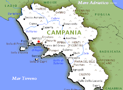
Campania Map Political Regions
Campania faces west and south-west on the Tyrrhenian Sea and borders with Lazio and Molise to the north, Puglia to the east, Basilicata to the east and southeast. Regional capital is Naples and that together with the provinces of Avellino, Benevento, Caserta and Salerno are the backbone of the Campania region depend administratively by the Neapolitan islands of Capri, Ischia, Procida (province of Naples).
It overlooks the Tyrrhenian Sea between the Garigliano River and the Gulf of Policastro, bounded in the interior of an irregular line that separates it from Lazio, Molise, Puglia and Basilicata. The coast, from very mild climate, friendly ports and mostly flat and very fertile land for the Romans was the region's wealth and happiness. Today's borders, however, include a bell is much wider and very different, very similar to the lands of central and southern Apennines, with its rugged mountains and barren, deserted landscapes and difficult crossings. The Campanian Apennines began in Molise, in Bocca di Forlì (998 m), and ends in the Saddle Conza (700 m) on the border with Basilicata, here begins the Appennino Lucano, part of which exceeds the boundaries, drawn by man, and enters the territory of Basilicata Campania. In Campania prevail throughout the limestone, with a marked and striking karst underground hydrography, in particular caves are famous both in the mainland, "Emerald Cave" near Amalfi and islands, the "Blue Grotto" in the island of Capri.
The plains, which cover less than one sixth of the territory are all coastal and alluvial origin, made from particularly fertile volcanic soil. To the north lies the plain and the wider meaningful name, the Terra di Lavoro, crossed the Volturno River to the south lies the plain of the Sele river, crossed by the river itself.


No comments:
Post a Comment