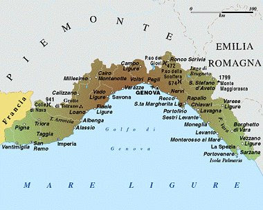
Liguria Map Political Regions
Liguria is overlooking the Ligurian Sea to the south and is bordered by France to the west, Piedmont to the north-west, Emilia-Romagna to the north-east and east of Tuscany. It is distributed in the provinces of Imperia, La Spezia, Savona and Genoa, which is also the regional capital
The region occupies the Tyrrhenian side of the Maritime Alps and the Ligurian Apennines, which are welded to the hill of Cadibona and form, the basin of Roia west to the east of the Magra, a large arch that encloses the Gulf of Genoa. There are no flat areas, because the findings come down to the sea, on which almost everywhere are thrown sheer. There are only two small plains, formed by alluvial deposits at the mouth of two rivers, respectively Centa and Entella: that of Albenga, in the province of Savona, and that of Chiavari, near Genoa. To the west of Genoa extends the so-called Riviera di Ponente, in many places bordered by narrow, sandy beaches, the coastal strip east of the city is called for against the Riviera di Levante, and is characterized by numerous headlands and accented with rare and small beaches.
The territory of Liguria is two-thirds mountainous and hilly for the rest. The alpine section proper, which covers the western part of the region, is represented by the Maritime Alps, which affect the 2200 m. with Saccarello; conventionally Colle di Cadibona, located just 435 m. share, is listed as a connection point between the Alps and the Ligurian Apennines. It is therefore the entire Apennine section of Central and East of Liguria, and covers the 1799 m. Maggiorasca with Mount, near the border with Emilia-Romagna. Several passes are usually easier in the winter months because, given their low elevation, are rarely blocked by snow. The passage of Jupiter, with a height of 472 m, is of particular importance because it connects Genoa to Milan and the main cities of the Po Valley.


No comments:
Post a Comment